
How to find an EV charging site: grid, chargers and planning
 Takeshi · 20 November 2026 · 6 min read
Ask anyone who has tried to build a charging hub what killed their last site and you'll usually hear the same word. Power. You can have a corner plot on an A-road with queues at the nearest rapid charger, and none of that helps if the substation down the road is already full.
So that's where we start. After the grid, check who's already charging in the area, then what the council has said yes and no to. Only then is it worth tracking down the owner. The examples below are from Surrey (Guildford, Woking, Horsell) and use the EV layers we've just added to Landicia.
1. Check the grid capacity
Rapid chargers draw a lot of power. If the local network can't take the extra load, the operator has to reinforce it before you connect, and that can add time and money you hadn't budgeted for.
What you want to know is the headroom at the nearest primary substation, meaning what's left once current demand and everything already promised to other projects is taken off. Every network operator publishes this. The trouble is there are six of them, each with its own map and its own way of presenting the numbers, so comparing two areas that sit either side of a boundary is a pain.
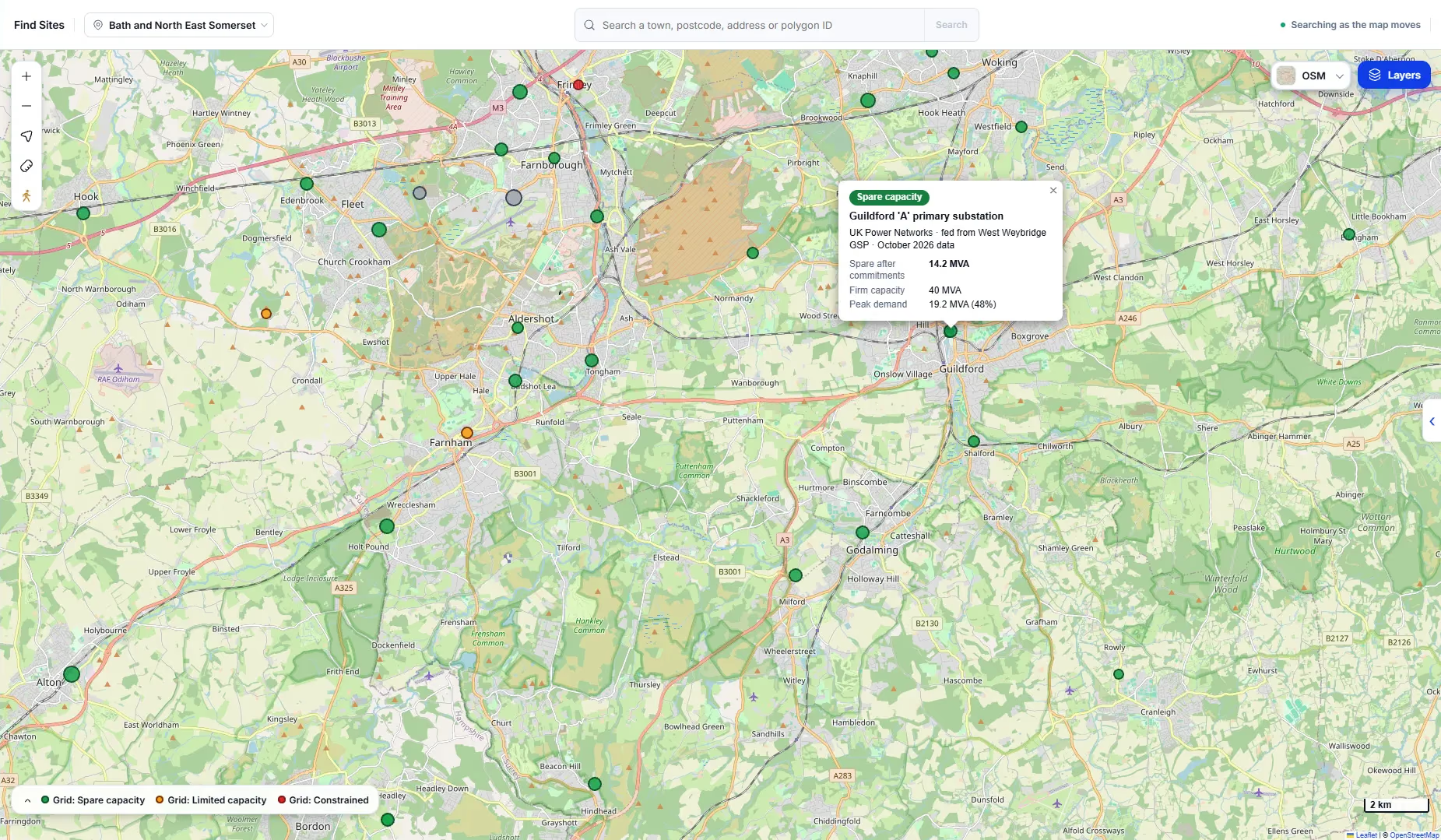
Our grid headroom layer pulls all six onto one map. Bigger dot, more spare power. The colour is the operator's own rating, where they give one.
Take Guildford 'A', a UK Power Networks substation. Firm capacity of 40 MVA, peak demand of 19.2 MVA, and 14.2 MVA left after commitments. Ignore the first figure and look at the last. Capacity that's been promised to someone else is no use to you, even if nobody has plugged in yet.
Zoom out and the area around Guildford is mostly green. There's orange near Farnham and Odiham, and one red dot up at Frimley. Look for green close to your land. A green substation four kilometres away is still a long cable run, and you'll be paying for it.
One caveat, and it's an important one: these numbers are a guide. They tell you where it's worth looking. Only an application to the network operator gets you a real answer and a price.
2. Map the chargers that are already there
Power sorted, the next question is who you'd be competing with. If there's already a rapid hub at the next junction, why would a driver stop at yours?
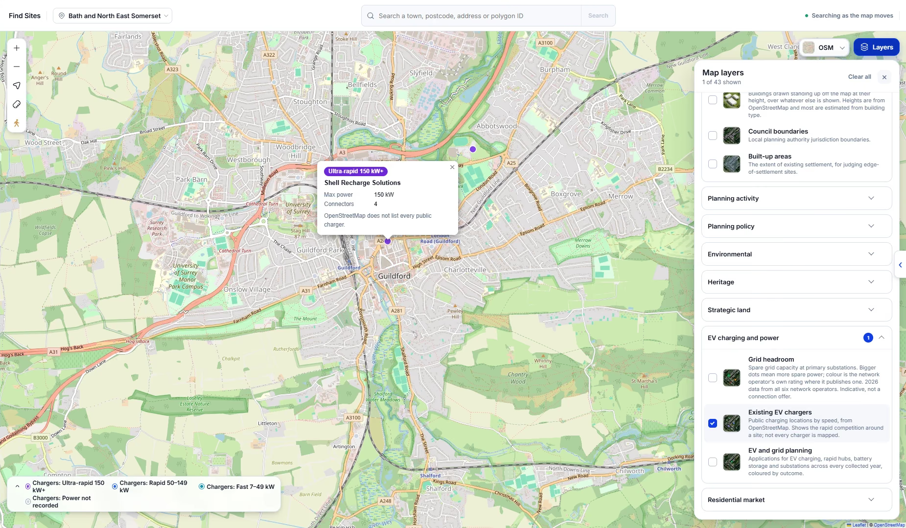
The existing EV chargers layer marks public charge points by speed. Ultra-rapid is 150 kW and up, rapid is 50 to 149 kW, fast is 7 to 49 kW. Click a point for the operator, the power and how many connectors it has. The one in the screenshot is a Shell Recharge site in central Guildford, four connectors at up to 150 kW.
Don't count points, look at speeds. Plenty of towns have dozens of 7 kW posts in council car parks and nowhere at all to charge in twenty minutes. That's the gap. Main roads, retail parks, food stores, anywhere people already stop for half an hour without a rapid charger nearby.
A word of warning on the data. It comes from OpenStreetMap, and OpenStreetMap misses some chargers. Before you write a site off (or get excited about one), check a charging app too.
3. Read the EV and grid planning history
Last check: planning. What's been applied for nearby, and what happened to it?
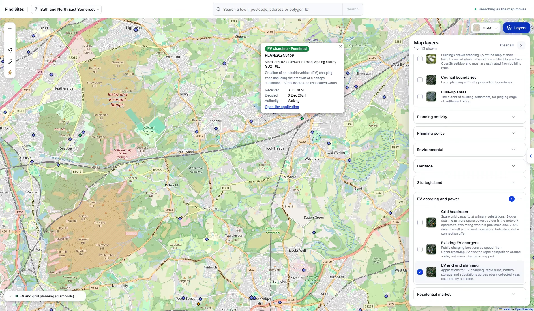
The EV and grid planning layer shows applications for charging, rapid hubs, battery storage and substations as diamonds, coloured by outcome. Click one and you get the reference, address, description and dates, plus a link through to the council's own record.
The one above is the Morrisons on Goldsworth Road in Woking. They applied for a charging zone with a canopy, a substation and an LV enclosure in July 2024, and Woking approved it that December. If you're eyeing up a similar site in the same borough, that's a decent sign.
Refusals tell you just as much, sometimes more. Open the decision notice and read why. Pending applications are worth a look as well, because someone may be a few months ahead of you on the same idea. And keep an eye on battery storage and substation schemes. They can mean grid upgrades are coming, or that someone else is after the same capacity you are.
On whether you need permission at all: some smaller charge points are permitted development, and those rules were last updated in May 2025. A proper hub with a canopy, a substation or a new access almost always needs full permission. The Woking scheme did. If in doubt, ring the council's planning team.
Find the owner
A site that gets through all three checks is worth chasing, so now you need to know who owns it. Click the title in Landicia and the site panel shows the area, the planning on and around it, and the owner if we can match one.
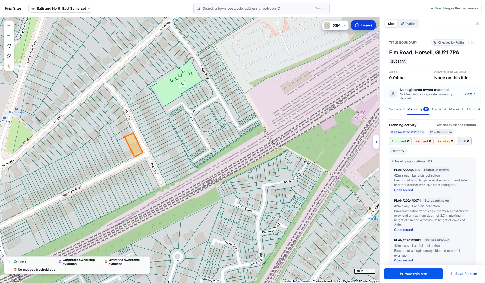
Here's a 0.04 ha title on Elm Road in Horsell. No planning on it, 12 applications within 250m, and no company owner matched. That usually means it belongs to a private individual, so you'll want the title register from HM Land Registry. It's £7 and gives you a name and an address for service.
If a company owns it, you'll see the company and its Companies House record instead. Our guide to finding out who owns land goes through both.
Then you write to them. There's a letter to a landowner template you can copy, and in Landicia you can draft and post the letter straight from the site.
Questions people ask
Do you need planning permission for an EV charging point?
Sometimes. A wall-mounted charger or a small upstand can be permitted development if it stays within the size and position limits. Anything bigger, especially with a canopy, a substation or a new access, will usually need full permission. The council can tell you which side of the line you're on.
How do I check grid capacity for EV chargers?
Each network operator publishes headroom figures for its substations. Landicia shows all six operators on one map. Treat the numbers as a starting point, though. You only get a firm answer, and a cost, by applying to the operator for a connection.
What makes a good EV charging site?
Spare power nearby, drivers who'll stop long enough to charge, not much rapid charging around already, and a council that has approved similar schemes.
How do I find land for EV charging?
Work outwards from substations with spare capacity. Cross off anywhere already well served by rapid chargers, then check the planning history. Edge-of-town land near main roads, under-used car parks and commercial sites with room to spare are good places to start.
How do I find out who owns land for an EV charging site?
See if a company owns it first, through Companies House or Landicia. If not, buy the title register from HM Land Registry for £7. It has the owner's name and an address to write to.
The EV layers in Landicia
Grid headroom, existing chargers, and EV and grid planning are all in the layers panel, under EV charging and power. If you'd like to see them on your own patch, book a 15-minute demo or have a look at the product.
See it on your own area
We load your target area before the call.