
Guide
SHLAA sites: how to find land your council has already assessed
 Takeshi · 25 September 2026 · 5 min read
Every council in England keeps a list of land it thinks could take new homes. It is called a SHLAA (Strategic Housing Land Availability Assessment), or a HELAA now that most councils assess employment land in the same document. It is public and it is mapped. It is also long, and most of it is tables.
It is worth the effort, because a SHLAA is a council telling you, site by site, what it thinks of land in its area. This guide covers what is in one, what it does not tell you, and how we use the SHLAA layer in Landicia to get from the council's list to the owner of a specific title. If you have read a few SHLAAs already, skip to finding SHLAA sites in Landicia.
What a SHLAA is
National planning guidance asks councils to identify "a future supply of land which is suitable, available and achievable for housing and economic development uses over the plan period". The SHLAA is the evidence for that. It feeds the local plan and the council's five-year housing land supply.
Sites get in two ways. The council does a desktop search of its own, and it runs a "call for sites" where landowners, agents and developers put land forward. Guidance suggests looking at anything that could take five or more homes.
Each site is then judged on whether it is suitable, available and achievable. Suitable means a sensible location given the constraints. Available means the council knows of no legal or ownership problem. Achievable means there is a reasonable prospect of it being built. Sites that pass are sorted by when they could come forward: within five years (deliverable) or later in the plan (developable). The council publishes the list, the maps, its assessment of each site and its reasons for ruling any out.
What it does not tell you
The guidance is blunt about this: the assessment "does not in itself determine whether a site should be allocated for development". Being in a SHLAA is not a planning permission, and being left out does not rule one out.
A few things to watch:
- Check the date. A 2019 assessment can be badly out of step with what has happened on the ground since.
- "Available" is the council's view when it wrote the report. Land put forward in a call for sites often has an agent or promoter behind it already. Land the council marked unavailable might just have an owner nobody has written to.
- Read the reasons for discounted sites. Green belt and flood risk rarely change. An unknown owner, or access that depends on a neighbouring parcel, is the kind of problem a developer can actually solve.
Finding SHLAA sites in Landicia
In Find sites, open Layers and search for "shlaa". The SHLAA / HELAA sites layer sits under Strategic land. Switch it on and every council-assessed site in view is drawn on the map.
The layer can be filtered by the council's verdict, normalised so it means the same thing from one authority to the next: Local Plan allocation, promoted for development, deliverable, developable, permitted, under construction, completed, not developable, excluded, or assessment unclear. If you only want land the council has already allocated, tick that and hide the rest. If you are looking for the ones other people have walked past, "not developable" and "assessment unclear" are worth a look too. So are the edges of the big promoted sites: the council's line often takes in a few small titles that the promoter has no hold on.
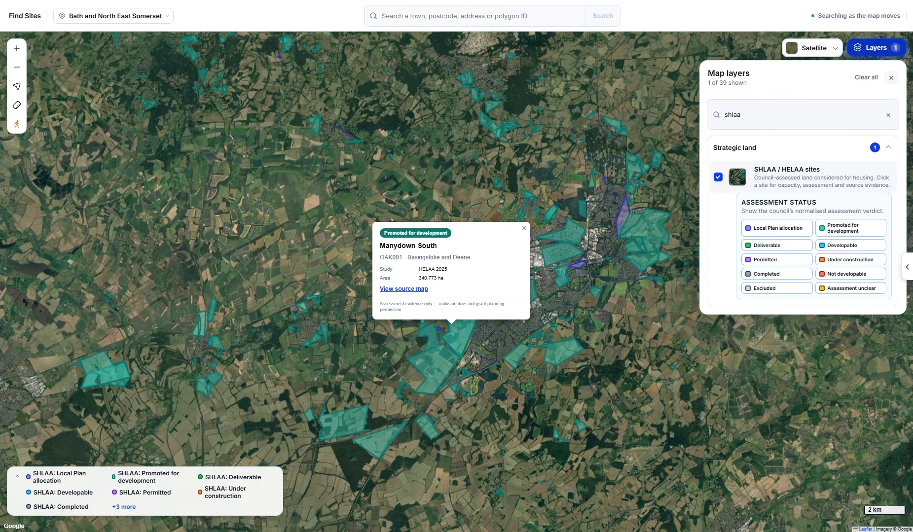
Click a site and you get its status, name, reference, council, which study it came from and its area. In the example above that is Manydown South, reference OAK001, from Basingstoke and Deane's HELAA 2025, at a little over 340 hectares. "View source map" takes you to the council's own document, so you can check the boundary and read the assessment in the council's words.
From the council's site to the title
A SHLAA site is drawn round the land the council assessed, not round anyone's ownership. A big one can cover a dozen titles. So the next step is to zoom in, turn on title boundaries alongside the SHLAA layer, and see how the registered titles sit inside the council's line.
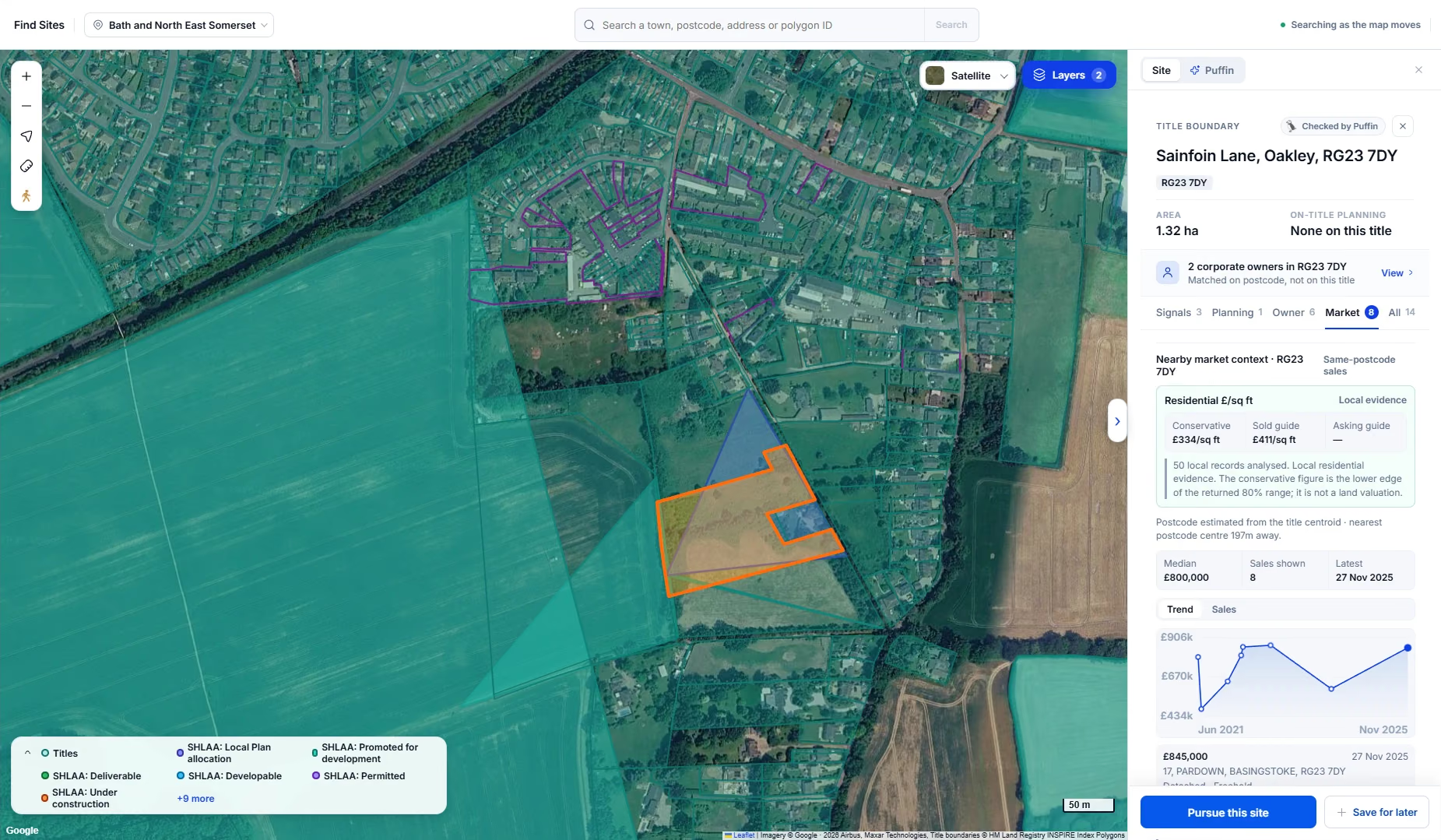
Here we have selected a 1.32 hectare title at Sainfoin Lane, Oakley. The side panel shows what the SHLAA cannot:
- whether anything has been applied for on the title (nothing, here), with the planning tab listing applications on and around it
- who owns it, or where Landicia can only match owners on the postcode, a clear note saying so
- what homes nearby have sold for, per square foot, with the range and the underlying sales
In this case two corporate owners are matched on the postcode but not on the title itself. That is useful to know before you write a letter to the wrong company, and it is where a £7 title register from HM Land Registry earns its keep.
Taking it forward
If the title looks worth pursuing, press Pursue this site, or Save for later if you want to come back to it. Either way it goes into My Sites. We would suggest a group per council assessment, so a batch of Basingstoke and Deane HELAA sites stays together.
From the saved site you can check the title with HM Land Registry, write to the owner, and post the letter through Landicia or print it yourself. When the owner replies, the response is recorded on the site.
Source: Housing and economic land availability assessment, Planning Practice Guidance, GOV.UK.
See it on your own area
We load your target area before the call.