
SHLAA vs brownfield register: which is better for finding sites?
 Takeshi · 29 October 2026 · 5 min read
If you are looking for development land in England, two council records come up again and again: the brownfield land register and the SHLAA. Both list sites that could take housing, but they are made for different reasons and tell you different things.
This guide explains what each one is, the pros and cons of both, and when to use which.
What is a brownfield land register?
A brownfield land register is a list of previously developed land that the council thinks is suitable for housing. Every council in England has to publish one and review it at least once a year. Sites are usually at least 0.25 ha or able to take five or more homes.
The register has two parts. Part 1 is the main list. Being on it does not grant planning permission. Part 2 is a smaller list where entry grants permission in principle, although technical details consent is still needed before anything can be built. The brownfield register guidance explains both.
Councils publish their registers in a national data standard, so you usually get the same fields wherever you look: site size, planning status, an estimate of how many homes it could take, and whether the land is publicly or privately owned.
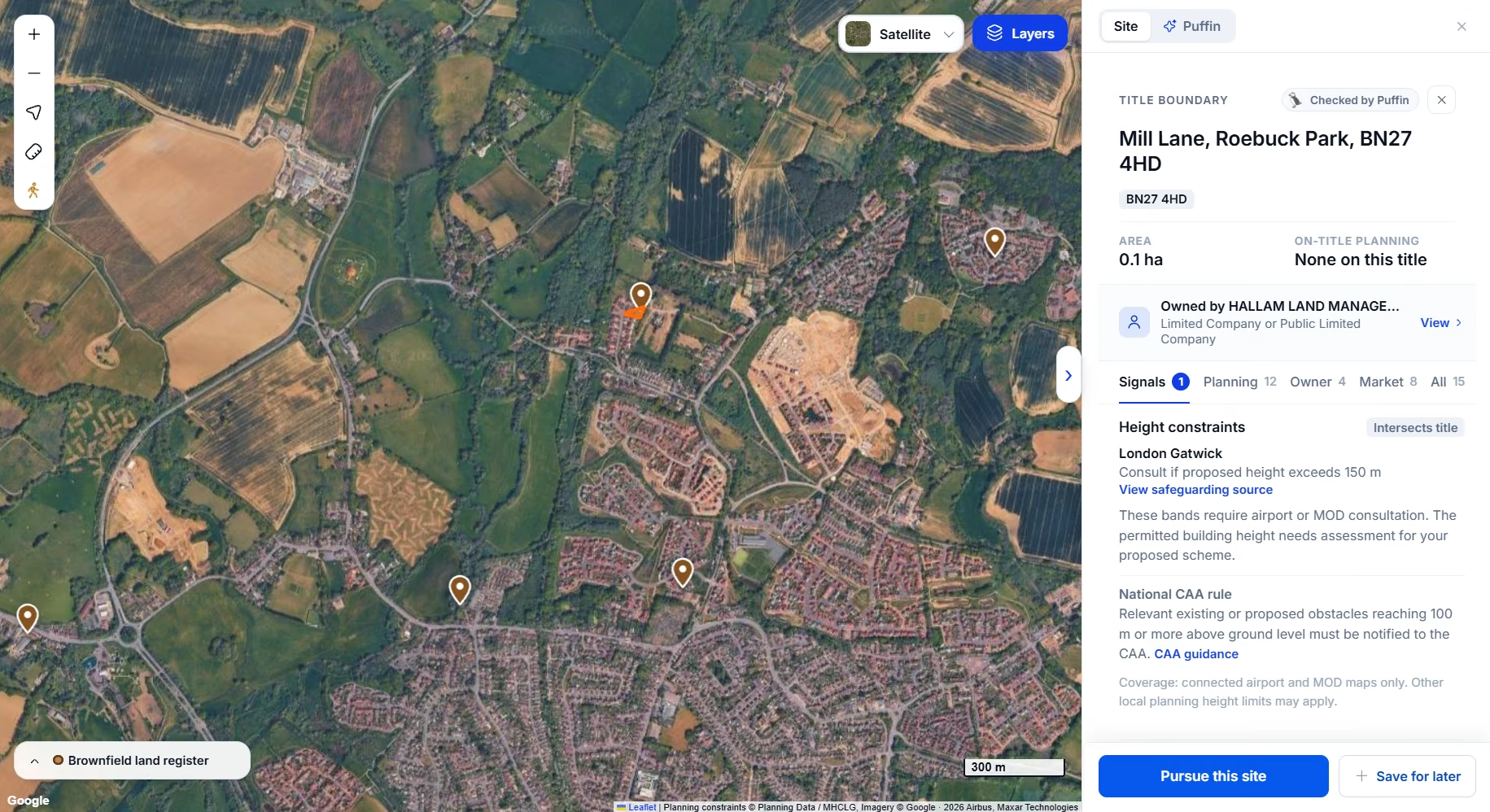
On the Landicia map, register entries show as pins. Selecting the land next to a pin opens its title, owner and planning history.
What is a SHLAA?
A SHLAA (Strategic Housing Land Availability Assessment) is the council's study of land that could be used for housing. Many councils now publish a HELAA instead, which covers housing and economic land. The council uses it as evidence when writing the local plan.
Landowners, promoters and developers put sites forward, and the council assesses each one. It records whether the site is suitable, available and achievable, and gives a conclusion such as deliverable, developable or not currently developable. Being in a SHLAA does not allocate a site or grant permission. The land availability assessment guidance has the detail, and our guide to finding SHLAA sites shows how to search them on a map.
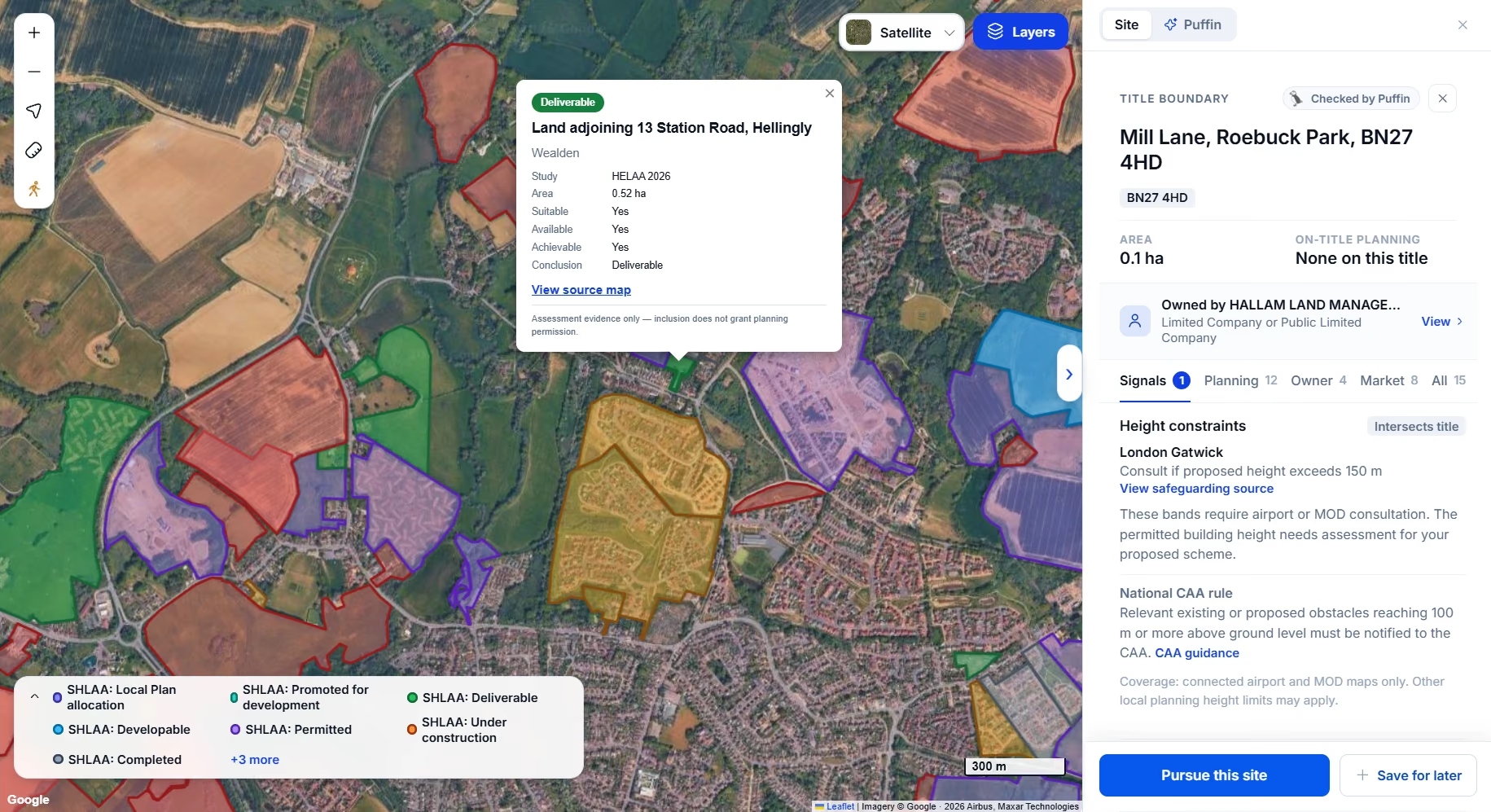
The example below is from the Wealden HELAA 2026. Land adjoining 13 Station Road, Hellingly, covers 0.52 ha and is marked suitable, available and achievable, with the conclusion "deliverable".
Brownfield register: pros and cons
Pros
- Up to date. Councils have to review it every year, so it is usually more current than a SHLAA.
- Consistent. Registers follow a national data standard, so you can search across areas without learning a new format each time.
- Policy is on your side. National policy gives substantial weight to using suitable brownfield land in settlements for homes.
- Some sites already have permission in principle. Part 2 entries have taken the first step towards consent.
- Ownership type is included. You can see whether the council thinks the land is publicly or privately owned before you look up the title.
Cons
- Brownfield only. Greenfield and edge-of-settlement land is not on it.
- Often just a point. Many entries do not show a boundary, so you need to work out which titles the site covers.
- Many sites are already moving. A lot of entries already have planning permission or are under construction, so they are not available to buy.
- Small sites are often missing. Land under 0.25 ha that cannot take five homes usually is not listed.
SHLAA: pros and cons
Pros
- Covers all land. Greenfield, brownfield and edge-of-settlement sites are all included.
- You see the council's thinking. Each site has a verdict and usually the reasons, such as access, flood risk or landscape.
- Boundaries are drawn. Outlines make it easier to match a site to the titles it covers.
- A clue to future allocations. Sites rated deliverable or developable are the ones the council may allocate in its next plan.
- Shows owners who want to sell or develop. Most sites were put forward by the owner or a promoter, so someone has already said the land is available.
Cons
- Can be out of date. Some councils have not updated theirs for years, so check the date before relying on it.
- Every council does it differently. Formats, names and scoring vary, and many are long PDFs.
- Often already promoted. If a promoter or housebuilder submitted the site, they may already have an option on the land.
- No permission. A good score is the council's opinion at the time. It is not an allocation or a planning consent.
Which should you use?
Use the brownfield register when you want previously developed sites in towns, a consistent list across several councils, or sites that already have some planning status.
Use the SHLAA when you are open to greenfield land, want to know how the council sees a site, or are looking for land that could be allocated in the next local plan.
Use both when you can. A site that is on the brownfield register and rated deliverable in the SHLAA has had two council checks. Just make sure both records cover the same land, and check the date on each one.
Whichever you start with, neither record tells you who owns the land or whether they will sell. For that you need the title register. Our guide to finding out who owns land walks through it.
Search both in one place
Landicia shows brownfield register entries and SHLAA and HELAA sites on one map, alongside title boundaries, owners and planning history. You can see a site on both layers, check who owns it and save it to your pipeline. See how it works on the product page.
If you would rather we did the searching, Landicia Assisted finds and reviews sites against your brief, using the brownfield register, SHLAA sites, planning applications and more.
Official sources checked on 29 October 2026. Council records and planning decisions need checking separately for each site.
See it on your own area
We load your target area before the call.